Filter by:

Filter by published date

A map dedication from Osgood Carlton "to the select men of the town of Boston" in 1795.

Practical Knowledge and the New Republic

Osgood Carleton and his forgotten 1795 map of Boston.
An inaccurate Spanish map from the 1500s of the southeast of the United States.

To Understand Mississippi, I Went to Spain

The forces that would shape my home state’s violent history were set in motion by a 480-year-old map made by a Spanish explorer.
1905 Sanborn insurance map of San Francisco, damaged by the fires after the 1906 earthquake.

From Fire Hazards to Family Trees: The Sanborn Fire Insurance Maps

Created for US insurance firms during devastating fires across the 19th and 20th centuries, the Sanborn maps blaze with detail the aspects of American cities.
The Castello Plan map, depicting the broad way (Broadway) and the Wall (Wall Street)

This New York City Map Is Full of Dutch Secrets

When Broadway was a broad way and Wall Street was a wall.
1970 Map of the United States Interstate Highway Plan

How Black Activists Have Long Used Mapmaking to Document Culture and Racism in the U.S.

The neglected history of Black mapmaking in America and the creative ways in which Black people have historically used mapping to tell stories.
John Mitchell's 1755 map of the British colonies in North America.

Defining the Northwestern Limits of the New Republic

John Mitchell's renowned 1755 map was a part of King George III's extensive collection of topographical charts that helped shape American designs on Canada.
A modern paper map of Boston, marked with Sharpie lines.

Boston's Map, Explained

Boston has more "made" land than any other American city.
Society of Planning Officials tours the Freedom House.

Mapping Renewal, Engaging Residents

Reflections on Freedom House and citizen participation in Boston's urban renewal.
Detail of atlas of the city of Boston, Boston Proper and Back Bay, Plate 9.

Building Blocks

An exhibition exploring the connections between the environment and social justice, using maps and visual materials.
Map of Phillips Radio by Walter Eckhard (1935).

The Spirit of Radio

Explore some new and old radio maps in our collection, and learn a bit about the history of radio communications.
The United States of America, or as it’s also known: New York’s “back yard”.

Satirical Cartography: A Century of American Humor in Twisted Maps

Satire and an inflated sense of self-importance collide in a series of maps that goes back more than 100 years in American history.
Thomas Kitchin's 1760 map of the "Cherokee Nation".

The Remapping of America—From an Indigenous Point of View

New maps can revive Cherokee place names in Southern Appalachia and restore crucial knowledge amid an environmental catastrophe.
1885 Map of St. Louis

Explore 'Mapping LGBTQ St. Louis'

This digital exploration of the region's LGBTQ community from 1946 to 1992 includes an interactive map and several thematic StoryMaps.
Collage of maps representative of the project
partner

Southern Journey: The Migrations of the American South 1790-2020

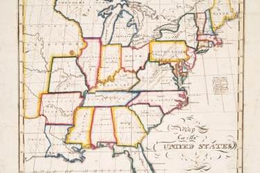
The maps embrace everyone —free and enslaved, from the first national census of the late 18th century to the sophisticated surveys of the early 21st century.
Geological map of winding river paths creating an intricate swirling pattern

Harold Fisk’s Meander Maps of the Mississippi River

A geologist and cartographer dreamed up a captivating, colorful, visually succinct way of representing the river's fluctuations through space and time.

These Newly Digitized Military Maps Explore the World of George III

The last British monarch to reign over the American colonies had a collection of more than 55,000 maps, each with their own story to tell.

Mapping Non-European Visions of the World

These maps drawn by Indigenous artists depict a union of visual traditions during the 16th century.
Painting of people examining a globe that depicts California as an island.

California, an Island?

Meet cartography's most persistent mistake.
original

The World According to the 1580s

A newly digitized map offers a rare glimpse at the way Europeans conceived of the Americas before British colonization.
Street in Chinatown, Los Angeles

Remapping LA

Before California was West, it was North and it was East: an arrival point for both Mexican and Chinese immigrants.
Map of U.S. in pastels, with Benjamin Harrison and the words "Protection to American Labor" at the center.

These 'Persuasive Maps' Aren't Concerned With the Facts

A digital collection shows how subjective maps can be used to manipulate, rather than present the world as it really is.

In Its First Decades, The United States Nurtured Schoolgirl Mapmakers

Education for women and emerging nationhood, illustrated with care and charm.

How Maps Reveal, and Conceal, History

What one scholar learned from writing an American history consisting of 100 maps.

America’s First Female Mapmaker

Through Emma Williard's imagination, a collection of rare maps that illustrates past reality.

Illustrated Maps of New York Through the Ages

A selection of illustrated maps of New York spanning six centuries.

Russians Were Once Banned From a Third of the U.S.

Soviet ban? What Soviet ban?
Map showing the U.S. broken up into four countries, including an expansive Confederate States of America.

A Map of the Disunited States, "as Traitors and Tyrants Would Have It"

The U.S. divided into Pacific, Atlantic, Interior and Confederate States.

The Strange Ratio of Treasure Island

The perfect correspondence of landscape and information can be seen in Ruth Taylor’s 1939 map.

How Advertisers Have Used Maps to Try to Sell You Stuff

A huge collection of “persuasive maps” — newly available online — reveals how our trust in cartography can be used to sway us.

Native Land Digital

Do you live on Native American territory?

Filter Results:

Suggested Filters:

Idea

Person